Sea to Sky Highway - A Day Trip
by Dad
Activity
The Sea to Sky Highway is the name given to the stretch of Highway 99 that snakes along the cliffs of Howe Sound from Horseshoe Bay in West Vancouver to the town of Squamish about 45 kilometres north. We woke to a beautiful sunny July morning and decided to drive up to Alice Lake for a swim. Alice Lake is about 10 kilometres north of Squamish. If you've never driven on the Sea to Sky Highway, you're in for a real treat. The highway combines the key ingredients for a great day trip: staggering views, Norwegian-like fjords, islands jutting out of Howe Sound, picturesque Browning lake, tumbling creeks, spectacular Shannon Falls , intriguing BC Museum of Mining , glaciers, Diamond Head mountain, the Stawamus Chief granite monolith, winding roads, and historical stops.Age Group
All agesExpense Rating
I'm going to say about five to ten dollars per person to cover gas. Plan on spending more if you stop for lunch, or if you visit the BC Museum of Mining .Thumbs Up
The stop offs along the Sea to Sky Highway have so much to offer: mountain climbing, hiking, fishing, swimming, and beautiful vistas of what makes British Columbia famous.Thumbs Down
Drive this highway carefully. People tend to speed on their way up to Whistler Mountain, and the winding road and changing weather conditions have claimed many lives over the years.Details
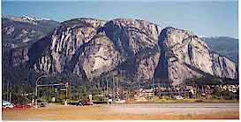
You need a car for this activity, although you can take the Royal Hudson Steam train up to Squamish. The train follows the same route as the Sea to Sky highway. Time allotment: although the drive from Horseshoe Bay to Squamish is only about one hour, you should plan about 5 to 7 hours for this day trip to allow for stop offs. We left at 11:30 am and returned home around 7:30 pm. In addition to the 1.5 hours we took for lunch at the Roadhouse Diner at Klahanie, we spent about 2 hours at Alice Lake swimming and pushing each other off our inner tubes. Here's what we did on our way to Alice Lake: We left Horseshoe Bay at 12:00 noon. (To get to Horseshoe Bay, cross either the Lions Gate Bridge or the Second Narrows Bridge from Vancouver, and travel west on Highway 99.) Once you reach Horseshoe Bay, reset your car's trip odometer to 0. At the 10 km mark you'll pass Lions Bay. Lions Bay is a small village of about 350 plus homes nestled on the cliffs over-looking Howe Sound. The island you see on the left is called Gambier Island. At the 18 km mark, you'll see an island jutting out of Howe Sound. It is called Anvil Island. Does it looked like an anvil to you? At the 24 km mark you come to Porteau Cove Provincial Park. A popular scuba diving park. Three large shipwrecks (one of the wrecks is a World War II minesweeper) have been sunk to create artificial reefs for divers. At the 32.5 km mark, you'll reach Britannia Beach, the site of the old Britannia Copper mine, now home to the BC Museum of Mining . The museum tour is very interesting, so if you've never been, try a visit. Nathe and Jen couldn't resist trying their hand at the gold panning trough. At the 36 km marker, you'll see a pretty small lake on your left. This is Browning Lake, part of Murrin Provincial Park. Apparently this park was donated by the old BC Electric Company, and Murrin was the name of the president of BC Electric from 1929 to 1946. The steep cliffs around the lake are a favourite spot for beginning or intermediate rock climbers. Possibilities: stop for a swim, hike, picnic, or do some trout fishing? At 41 km Shannon Falls Provincial Park comes up on your right. The falls are the third highest in the province. We ate lunch at the Roadhouse Diner at Klahanie. The diner has a great view of the falls. It was a nice sunny day so we had lunch on the outdoor patio. At the 42 km mark, you'll reach the Stawamus Chief Provincial Park. The Stawamus Chief is the second largest granite monolith in the world (a monolith is defined as a single great stone often in the form of an obelisk or column... trust me, I looked it up in the dictionary). It is second only to the rock of the Gibraltar. Stop the car, and try to spot climbers going up the sheer face. They are hard to spot at first, but keep looking, they're there. At 45 km, you'll reach the logging town of Squamish. It's a small town of about 15,000 residents. We keep the kids happy by stopping at the local "Golden Arches", and my dear wife has her day made with stop at Starbucks for a "tall, decaf, cappuccino, with a double shot of espresso, dry, sprinkle of cinnamon and chocolate, and that's to go". The Royal Hudson steam train also stops at Squamish in the summer. At 46 km, follow the sign and take a left if you want to visit the West Coast Railway Heritage Park . If it's winter time, you might want to visit the nearby dikes to view the Bald Eagles . Otherwise keep driving along highway 99 for another 6.5 km, and then take a right off the highway to Alice Lake. Alice Lake is about 1 km from the highway. Nestled in the mountains, it's one of the prettiest little lakes I've ever seen. Here you can enjoy the beautiful setting, fish, hike, or swim. Also check out Brohm Lake which is a couple kilometres past Alice Lake turn-off on Highway 99.Area
Squamish
Season
All seasons, but I recommend the summer, especially if you have swimming on your agenda.
Educational Highlights
The Stawamus Chief is the second largest hunk of granite in the world (Gibraltar is first). The Britannia Copper Mine was, at one time, the largest copper mine in the British Commonwealth. Shannon Falls is the third largest falls in British Columbia. Brackendale on January 9, 1994 set the world record count for bald eagles with more than 3,766 sightings.Fun for the Adult?
This day trip is lots of fun for both adults and kids. My wife and I really enjoyed the breakfast-style lunch at the Roadside Diner at Klahanie with its beautiful view of Shannon Falls. We all enjoyed swimming at picturesque Alice Lake. All in all a great day trip.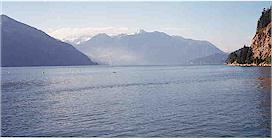
Porteau Cove: Three ships lie below these waters for divers to explore
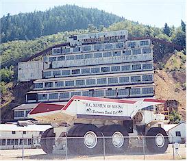
The old Britannia Copper mine is now a museum
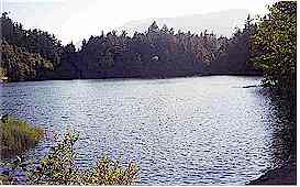
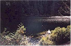
Pretty Browning Lake lies right alongside the highway
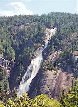
Shannon Falls as viewed from the Roadhouse Diner at Klahanie
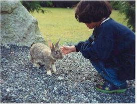
Jen had fun feeding the 'wild' rabbits that live near the Roadhouse Diner
at Klahanie
A climbing favourite: the Stawamus Chief
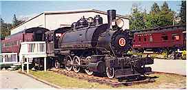
West Coast Railway Heritage Park
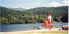
Our final destination: a swim at Alice Lake
Pleasant Brohm Lake is a couple kilometres past Alice Lake
© Triple F Family Adventures None